

Curry County
NMGenWeb

This county was created out of a portion of Chaves county, at one time a
portion of the vast domain of the county of Lincoln. It is in the heart of the
country described by the early Spanish explorer as being as far as the eye could
reach a land of "buffalo and sky."
The population in 1910 was 11,443. It
is on the eastern border of the State and is joined on the east by Parmer
county, Texas. It is in the very midst of the greatest body of fine agricultural
land known as the Panhandle. The county seat is Clovis. The acreage open to
entry under the United States Land Office at Fort Sumner, all surveyed, totals
15,214 acres; under the land office at Tucumcari, 2,054 acres.
The
principal cities and towns are: Clovis, population, 3,255, altitude, 4,200;
Melrose, population, 700; Texico, population 409.
The land throughout
this section is uniformly level. This is one of the rapidly developing sections
of the State and is an example of western growth where opportunities are
favorable. In 1906 the site of the city of Clovis was unbroken plain. Today
(1916) it has a population of not less than five thousand. It is located on the
main line of the Atchison, Topeka and Santa Fe railway at the junction of the
Chicago-to-the-Coast, the Pecos Valley and the Galveston-to-San Francisco lines
of the system. The city was founded and the first house erected in 1907, soon
after it was learned that this point was to be the junction point for the above
lines which were then under construction through this part of the State. Its
almost phenomenal growth has been due to its location in the heart of the plains
country, together with the railway company's construction here of very large
car-building and repair shops.
This part of the State has been and
probably always will be a dry-farming section, a method which has proven very
successful as evidenced by the prosperous communities in this county.
The
normal annual precipitation for the county is 19.7 inches; the normal seasonal
precipitation - from April to September - is 15.4 inches; the normal seasonal
snowfall amounts to 17.6 inches. The mean annual temperature is 56 degrees, the
mean winter 36 degrees and the mean summer 75 degrees.
Melrose, Texico,
Logansville, Preston, Prairie View, Grady, Hollene, Lewis, Field, Marsey, Haag,
Claud, Blacktower, St. Vrain, and Cantara are among the prosperous settlements
of the county.
Extracted from 1917 The Leading Facts of New Mexican History, Vol III, by Ralph E. Twitchell
Clovis, New Mexico was created by the AT & SF Railroad as a terminal on the
Belen Cutoff in 1906/1907. Actual construction was started east from Belen in
1902 when the Eastern Railway of New Mexico was formed to construct a railroad
between Amarillo and Belen through Abo Pass. This new route saved the AT & SF
Ry. about one half of a mile; however, this one half of a mile was nearly
straight up over the Glorietas and Raton Pass. Money problems of 1903 stopped
construction for a short time (approximately six months). A 1908 picture of
Clovis.
The first train on Hagerman's line, Pecos Valley and Northeastern
Railway operated through Texico, Portales, Roswell, Eddy (Carlsbad) about 1899.
AT & SF engineers were having substantial problems in locating an eastern
terminal for the Belen Cutoff. Locations considered were Melrose, Texico,
Blacktower, and even Portales thought they might be chosen. In 1906 these
communities were in Roosevelt County. These locations were not chosen.
Eastern Railway Company of New Mexico; TIME TABLE No. 1, in effect March 12,
1906, at 12:05 A. M. This Time Table shows the following stations west of Texico
listed in this order: TEXICO; CLOVIS; BLACK TOWER (later changed to Portair then
Gallaher); ST. VRAIN; MELROSE; CANTARA; IDRIA (later changed to Krider); TAIBAN;
La LANDE; and SUNNYSIDE (later changed to Ft. Sumner).
On Sept. 1, 1906,
W. B. Storey was appointed chief engineer of the AT & SF Railroad. One of his
first official acts after taking over as chief engineer was to wire the
engineers at Texico, "to located and buy the first level section of land west of
Texico for a townsite and facilities for the eastern terminal", of the Belen
Cutoff. The first level section of land west of Texico on the line that was
considered was Section 18, Township 2, Range 6 east. The SE quarter was owned by
Jack Blackwell; the SW quarter was owned by Oliver Todd; The NE quarter was
owned by Clayton Reed, and Clayton Reed's sister, Nellie Reed, owned the NW
quarter. This section of land was purchased in October 2nd of 1906, and work
started immediately to construct railroad facilities and the townsite for
Clovis. Clovis was in Roosevelt County when it was created by the AT & SF
Railroad.
The above original townsite of Clovis was bordered on the south
by Brady Street, on the east by Prince Street, on the north by Seventh Street,
and on the west by Thornton Street. The actual town was laid out to the north of
the AT & SF tracks and facilities. The approximately one half section south of
the tracks was used for railroad shops, feed and shipping yards, and other
railroad facilities. The AT & SF Railroad started construction on a roundhouse,
coal chute, and hotel.
On May 1, 1907, the Santa Fe Land and Improvement
Company opened sale on lots for the townsite of Clovis.
Clayton Reed is
reported to have built the first business in Clovis, a real estate office, in
May of 1907.
At a meeting of the Roosevelt County commissioners April 6,
1908, in a regular meeting ordered and decreed that the town of Clovis, said
county (Roosevelt), be a duly and regularly incorporated town. Shortly
thereafter it was recorded:
Whereas at said meeting, the said county,
ordered and decreed that an election be held in said town of Clovis on the
sixteenth day of May, A.D., 1908 for the purpose of electing a board of five
trustees of the said town of Clovis. Said election was held in accordance with
such order and decrees and the following persons elected, and qualified as such
board of trustees, to wit: R. C. Reid, chairman; W. B. Cramer; E. R. Hart; B. F.
Craig; and W. L. Mansfield. (R. C. Reid was the first Mayor of Clovis.) (F. T.
Tully was appointed clerk.)
Clovis was incorporated as a city on March 9,
1909 and the first elected school board was chosen with two members from each of
the four wards.
The Belen Cutoff which was built from Belen, NM to
Texico, NM at the Texas State line was started when the Eastern Railway of New
Mexico was incorporated on October 30, 1902 and was completed in February 1,
1912, when it was taken over by the Atchison, Topeka, and Santa Fe Railway.
New Mexico Governor Curry wrote, "the bill came to my desk on February 25, I
signed it promptly. There was considerable opposition to the Curry County bill,
in part over location of the county seat, for which there were several
contenders and also opposition because of the new county's then low assessed
valuation, at that time only about $1,750,00.....". Curry County was named for
Governor Curry.
A mystery!!! Many of the old timers refer to Clovis as
Riley Switch. The question most everyone wants to ignore is that Mr. R. C. Reid
who represented the Santa Fe Land and Improvement Company, bought four (4)
quarter sections of land that had been homesteaded on. A timetable for the
Eastern Railway Company of New Mexico in effect March 12, 1906 at 12:05 A. M
lists stations west out of Texico as Clovis, Blacktower, St. Vrain, Melrose,
Cantara, Idria, Taiban, La Lande, Sunnyside (later changed to Ft. Sumner). There
were sidings at each of these locations.
Question: If Clovis is listed
8.4 miles west of Texico in March of 1906, where does Riley Switch come into
play? According to Post Office records there was a post office by the name of
Riley in service for approx. six months in 1906-1907. Riley Post office was
located in a box car on the ground approximately 150 yards east of what is now
known as the corner of Prince street and Tatum Av. There was a switch, of
course, and this is what is referred to as Riley Switch.
Collected and
compiled May 1995 by Harold Kilmer, extracted from 1978 Curry County History
The town of Grady was started December 6, 1906. A Cassius C. Marshall,
Christopher G. Wells, and John W. French were the surveyors of this land
according to the abstract deed. Mrs. Pearl Grady gave the townsite to the people
if they would name the town Grady. The first grocery store was owned by Shorty
Harrel and it also had hardware and harness and an undertaking parlor. Clyde
Stanfield's father owned a store in Grady in 1906. A Carl Beck, a Mr. Todd, and
a Charlie Ash also owned stores in the early days of Grady.
In 1907 the
Grady cemetery was started. The land was given by Susan E. Davis. At one time a
Mrs. Sorenson ran a cafe in Grady. Mrs. Stanfield also ran a cafe for a while.
Rev. W. C. Grant organized the first church in Grady. It was a Baptist Church
and Rev. E. E. McNeal was the first. pastor.
Extracted from 1978 Curry County History
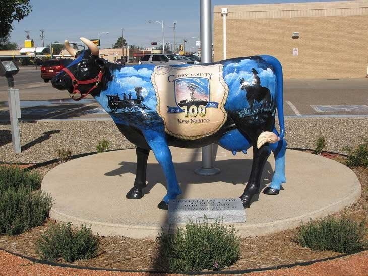
Centennial Cow
was created in honor of the 100th birthday of Curry County and is located on the
courthouse lawn, 700 North Main Street, Clovis.
Courtesy of L. J. Bowman, Jr. from virtualtourist.com
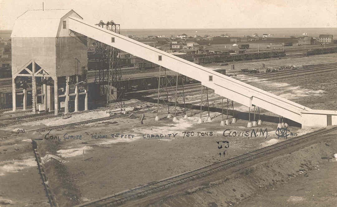
1908 Coal Chute at Clovis
Courtesy of Harold Kilmer
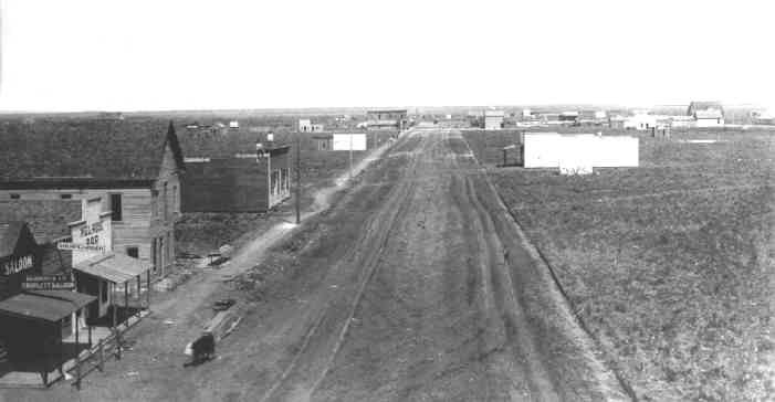
Main Street, Clovis
Courtesy of Harold Kilmer
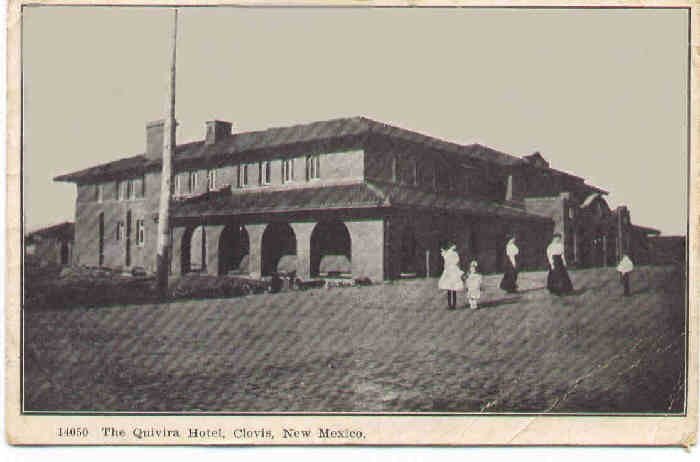
Quivira Hotel in Clovis
Courtesy of Harold Kilmer
Copyright © 1996 - The USGenWeb® Project, NMGenWeb, Curry County

This page was last updated
08/13/2026